  | 
          
            This is a file from the  Wikimedia Commons. Information from its  description page there is shown below.  Commons is a freely licensed media file repository.  You can help. 
           | 


            | 
          
            This is an image of a place or building that is listed on the  National Register of Historic Places in the United States. Its reference number is 74000349. 
           | 


           | DescriptionSkidoo in 1906.jpg | 
           
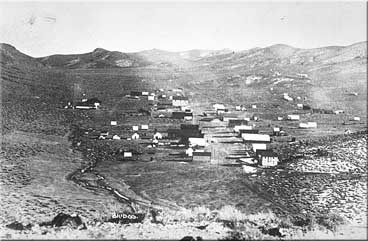
            English: The Town of   Skidoo in 1906 — within present day  Death Valley National Park.  
              - The discovery of gold at Skidoo in the early 1900's sparked Death Valley's third mining period.


              - 
               
                - "Town of Skidoo" from NPS archives.


            日本語: 1906年に撮影されたスキードゥーの風景. 
            Русский: Посёлок Скиду в 1906 году. 
            Български: Мината Скидо през 1906. 
            | 
          
          
           | Date | 
           1906 | 
          
          
           | Source | 
           US National Park Service 
            | 
          
          
           | Author | 
           
             This file is lacking author information. 
            | 
          
          
           Permission ( Reusing this file) | 


              | Public domainPublic domainfalsefalse | 


                | 
              This image is in the  public domain because it contains materials that originally came from the  United States Geological Survey, an agency of the  United States Department of the Interior. For more information, see  the official USGS copyright policy. 
                български |  català |  Deutsch |  English |  español |  eesti |  suomi |  français |  galego |  italiano |  한국어 |  македонски |  മലയാളം |  Nederlands |  polski |  português |  русский |  Türkçe |  中文(香港) |  中文(简体) |  +/− 
               | 
              
               
               | 
              
             
            | 


          | 
            Object location 
           | 
          
             36° 25′ 59.00″ N, 117° 7′ 46.00″ W 
           | 
          View this and other nearby images on:  Google Maps -  Google Earth -  OpenStreetMap -  Proximityrama | 
          ( Info)36.433056;-117.129444 | 


       File usage
       
        The following pages on Schools Wikipedia link to this image (list may be incomplete):


      Wikipedia for Schools is one of SOS Children's many educational projects. SOS Children is an international children's charity, providing a good home and loving family to thousands of children who have lost their parents. We also work with communities to help vulnerable families stay together and raise children in the best possible environment. Want to learn more? Go to http://www.soschildrensvillages.org.uk/sponsor-a-child